【题目】读我国主要山脉分布图及地形剖面图,回答问题。
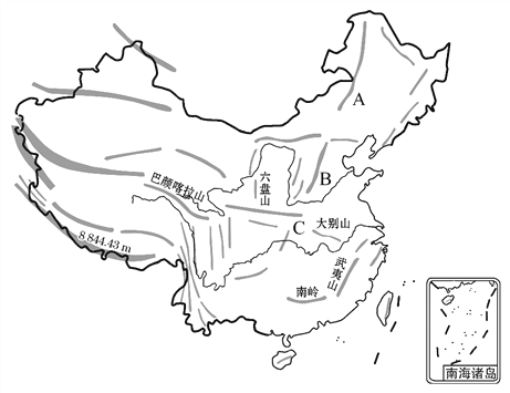
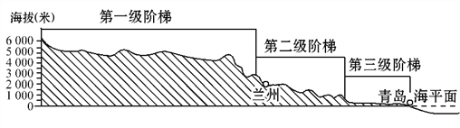
(1)由剖面图可以看出,我国地势特征是____________,呈三级阶梯状分布。
(2)字母A、B所示山脉是我国地势第二、第三级阶梯的分界线。其中,山脉A大致的走向是________________;山脉B的名称是________________。
(3)图中山脉C和淮河组成了我国重要的地理分界线,山脉C的名称是________。请列举该分界线的两项重要地理意义 。
科目:初中地理 来源: 题型:
【题目】读材料和“中国区域图及南海诸岛图”,完成下列各题。
材料:三沙市于2012年6月21日设立,是中国最南端的城市,为海南省第三个地级市,下辖西沙群岛、南沙群岛、中沙群岛的岛礁及其海域。
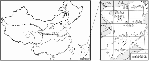
(1)据材料可知,三沙市所处的海域是 ,所在省级行政区的简称是 。相邻国家A的名称是 。
(2)长期以来,我国南海海域受到周边国家的非法占有和掠夺.试从资源方面简要分析其原因: 。
(3)图中B处山脉是 ,其东北部平原主要种植 。
(4)C地区主要是 业。主要农作物是_______(填字母)。
A、甘蔗 B、水稻 C、油菜 D、青稞
(5)按照我国干湿地区的划分,海南岛属于_________区,依据当地的自然条件除了可以发展种植业以外,还可以发展______业
查看答案和解析>>
科目:初中地理 来源: 题型:
【题目】当帕米尔高原还是满天星斗的黑夜时,乌苏里江面已洒满朝阳,造成这种差异的原因是
A.南北跨纬度广
B.东西距离长、跨经度大
C.离海洋远近不同
D.地形复杂
查看答案和解析>>
科目:初中地理 来源: 题型:
【题目】Einstein often received invitations to explain his theories at different universities. On these trips, his driver was always the same man called Hans. Hans often said to him. “It is a pleasure to drive a talent like you, Dr Einstein.”
One evening, on their way to a university, Einstein said, “I’m so tired. I wish I could refuse to give my lecture(讲座) tonight, Hans, but I don’t want to let my audience down.”
“I know what to do,” said Hans. “I can give the lecture for you. You can trust me. I’ve listened to your lecture so many times that I’ve learnt it by heart. No one knows you at this university, so they won’t find out.”
So, they changed places. At the university, Hans was guided to the front of the hall. Einstein took a seat, listened to Hans give his lecture without difficulty, and joined in the applause (掌声) at the end.
However, before Hans left, a man shouted, “I’d like to ask you a question.” He then asked a difficult question and Hans had no idea what he was talking about.
Einstein turned pale. “Oh no! ,” he thought. “Now we’re in trouble.” But Hans just laughed and said, “That’s such an easy question that even my driver can answer it. Hans, please…”
Einstein stood up and answered the question perfectly.
They left the university, with Einstein driving. A little later, Hans offered to drive. “No, ” laughed Einstein. “It’s a pleasure to drive a talent like you, Hans.”
【1】Which of the following is the most suitable for “ ”?
A. Lies have short legs
B. Rome was not built in a day
C. A miss is as good as a mile
D. Life is not all roses
【2】Just as the mind map, the story can be divided into five parts: opening, rising action, turning point, falling action and ending. Which do you think is the turning point of it?

A. Einstein answered the question perfectly.
B. A man asked a difficult question.
C. Hans offered to give a lecture for Einstein.
D. Hans asked Einstein to answer the question.
【3】What would be the best title for this story?
A. Great Minds B. An unforgettable Lecture
C. Two Talents D. An Easy Question
查看答案和解析>>
科目:初中地理 来源: 题型:
【题目】读“长江三角洲地区和珠江三角洲地区示意图”及B、C两城市“气温曲线和降水量柱状图”,回答下列问题。

(1)A、B、C、D、E五城市中,是我国最大城市、最大港口,也是国际经济、金融、贸易中心的是 ,与香港相邻的经济特区是 。
(2)图中①铁路线名称是 。
(3)与长江三角洲地区相比,珠江三角洲地区发展经济具有的独特地理位置优势是
。
(4)两地区修建核电站的主要目的是 。
(5)由B、C两城“气温曲线和降水量柱状图”可见,两地共同的气候特征是 。
查看答案和解析>>
湖北省互联网违法和不良信息举报平台 | 网上有害信息举报专区 | 电信诈骗举报专区 | 涉历史虚无主义有害信息举报专区 | 涉企侵权举报专区
违法和不良信息举报电话:027-86699610 举报邮箱:58377363@163.com
