【题目】读“某地区规划示意图”,回答下列问题。
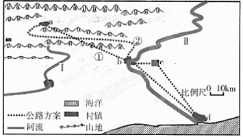
(1)图中西北部地区,优先选择的交通运输方式是_____________(选择填空)
A. 铁路 B. 公路 C. 水运 D. 航空
(2)计划修建从a村到b村的公路,有①②两条线路,你认为合理的线路是_____________,其理由是_____________(选择填空)
A. 路途短,经济效益高
B. 距离近,修建公路工程量小
C. 沿谷地修建,难度小,成本较低
D. 路途远,工程量大,成本高
(3)a、b两村相比更有可能发展成为城市的是_____________,影响其的主要自然因素是_____________。
科目:高中地理 来源: 题型:
【题目】福建某中学研究性学习小组,设计了可调节窗户遮阳板,实现教室良好的遮阳与采光。下图示意遮阳板设计原理,据此回答各题。
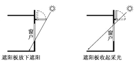
【1】
A. 全球昼夜平分 B. 北半球为夏季
C. 太阳直射20°S D. 南极圈以南地区极昼
【2】
①安装高度不变,加长遮阳板 ②安装高度不变,缩短遮阳板 ③遮阳板长度不变,降低安装高度 ④遮阳板长度不变,升高安装高度
A. ①③ B. ①④ C. ②③ D. ②④
查看答案和解析>>
科目:高中地理 来源: 题型:
【题目】下图为“北半球某海域洋流分布略图”。读图完成下列各题。
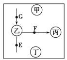
【1】
A. 向北,暖流 B. 向北,寒流
C. 向南,暖流 D. 向南,寒流
【2】
A. 东南风 B. 东北风
C. 西南风 D. 西北风
【3】
A. 甲 B. 乙 C. 丙 D. 丁
查看答案和解析>>
科目:高中地理 来源: 题型:
【题目】读“澳大利亚西部 某月份等温线分布示意图”。读图完成各题。
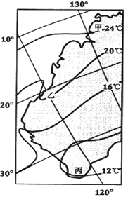
【1】
A. 洋流 B. 太阳辐射
C. 地形 D. 海陆分布
【2】
A. 北海道渔场 B. 秘鲁渔场
C. 纽芬兰渔场 D. 北海渔场
【3】
A. 热带雨林、热带草原、亚热带常绿硬叶林
B. 热带雨林、热带草原、亚热带常绿阔叶林
C. 热带草原、热带荒漠、亚热带常绿阔叶林
D. 热带草原、热带荒漠、亚热带常绿硬叶林
查看答案和解析>>
科目:高中地理 来源: 题型:
【题目】阅读理解。
|
Day school Program Secondary students across Toronto District School Board(TDSB) are invited to take one or two e-Learning courses on their day school timetable. Students will remain on the roll at their day school. The on-line classroom provides an innovative relevant and interactive Learning environment. The courses and on-line classroom are provided by the Ministry of Education These on-line courses
Benefits of e-Learning Include:
Is e-Learning for You? Students who are successful in on-line course are usually;
Students need to spend at least as much time with their on-line course work as they would in a face-to-face classroom course. |
【1】E-Learning courses are different from other TDSB courses in that .
A. they are given by best TDSB teachers.
B. they are not on the day school timetable.
C. they are not included on students’ reports.
D. they are an addition to TDSB courses.
【2】What do students need to do before completing e-learning courses?
A. To learn information technology on-line.
B. To do their assignments independently.
C. To update their mobile devices regularly.
D. To talk face to face with their teachers.
查看答案和解析>>
科目:高中地理 来源: 题型:
【题目】读下图,完成各题。
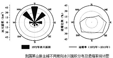
【1】该山峰最可能位于
A.横断山脉 B.秦岭
C.天山 D.台湾山脉
【2】造成不同坡向冰川面积差异的最主要因素是
A.降水 B.气温
C.光照 D.地势
【3】造成不同坡向冰川面积变化的最主要原因是
A.降水减少 B.气温升高
C.风力增强 D.地壳运动
查看答案和解析>>
科目:高中地理 来源: 题型:
【题目】--- We haven’t been to the Great Wall for ages.
--- No, I don’t remember how many years ago I last visited it.
A. it was that
B. was it that
C. it was when
D. was it when
查看答案和解析>>
科目:高中地理 来源: 题型:
【题目】【来源】【百强校】2016届北京市海淀区高三下学期期中练习英语试卷(带解析)
假设你是红星中学高三学生李华。请根据以下四幅图的先后顺序,给校刊“英语园地”写一
篇短文,介绍上周你与外国朋友Tom 在颐和园的经历。
注意:词数不少于60。
提示词:毛笔a writing brush
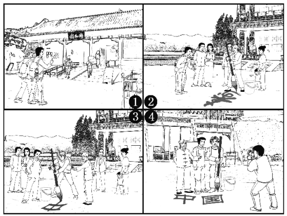
(请务必将作文写在答题卡指定区域内)
查看答案和解析>>
科目:高中地理 来源: 题型:
【题目】下图为我国某城市简图,该城市主导风向为东北风,读图完成下列各题。
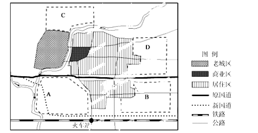
【1】工业区最适宜布局在
A.A区 B.B区 C.C区 D.D区
【2】国道改道的主要原因是
A.与火车站对接,实现铁路公路联运
B.城市土地价格的上涨
C.推动郊区城市化,带动郊区经济的发展
D.缓解城区的交通拥堵和大气污染
查看答案和解析>>
湖北省互联网违法和不良信息举报平台 | 网上有害信息举报专区 | 电信诈骗举报专区 | 涉历史虚无主义有害信息举报专区 | 涉企侵权举报专区
违法和不良信息举报电话:027-86699610 举报邮箱:58377363@163.com